ARCS
Admiralty Raster Chart Service
Admiralty Raster Chart Service (ARCS) makes nautical charts offered by the United Kingdom Hydrographic Office (UKHO) portfolio available in a convenient electronic format. Wide-ranging, official coverage of global commercial shipping routes, major ports and harbors with many scales and a selection of over 3,000 charts is available. To provide maximum flexibility, ARCS charts are available to be licensed on a chart by chart basis. Mariners need only pay for charts required.
The ADMIRALTY Raster Chart Service (ARCS) provides raster chart coverage of international shipping routes, main ports and harbours in a comprehensive range of scales. Ideal for both bridge crews and shore based users, it combines the familiarity of traditional ADMIRALTY paper charts with the precision of satellite positioning to support decision making.
Key features of ARCS include:
-
Familiar, clear and easy-to-use digital charts, helping bridge crews to understand critical information at moments of peak workload and pressure
-
Extensive coverage of international routes and ports in a comprehensive range of scales
-
Weekly ADMIRALTY Notices to Mariners (NMs) updates to support safe navigation
-
Compatible with a wide range of office based systems enabling cost-effective digital charting for shore-based users
Find out more about the features of ARCS >
Here to help
Once you’ve chosen ARCS we can offer you guidance to help you get the most from the service, with further support available from our in-house customer service team.
Find out more about support for ARCS >
Familiar, clear and easy to use
ARCS charts display the same imagery and symbols as traditional ADMIRALTY Standard Nautical Charts (SNCs). This familiarity, combined with accurate satellite positioning in an ECS or ECIDS navigation system, can improve situational awareness and help bridge crews to understand critical information at moments of peak workload and pressure.
Global coverage
With over 3,000 official charts available, ARCS provides extensive raster chart coverage of international shipping routes, main ports and harbours in a comprehensive range of scales.
By combining the wide coverage, familiarity and ease-of-use of ARCS with AVCS, you can get the most comprehensive and trusted digital chart service available for ships trading internationally.
Efficient weekly updates, including T&P NMs
Weekly updates ensure that bridge crews and shore-based teams have access to complete and up-to-date information. All ARCS customers can receive these updates via internet or CD, with the latest ADMIRALTY Notices to Mariners (NMs) applied easily and accurately in a matter of seconds. The weekly updates also include all Temporary and Preliminary Notices to Mariners (T&P NMs) generated by the UKHO’s extensive quality assurance processes.
These electronic updates reduce time and effort spent making manual updates to paper charts and minimise the risk of human error.
Official Raster Navigational Charts
ARCS is an RNC service containing digital raster copies of official ADMIRALTY paper charts, conforming to the International Hydrographic Organization (IHO) Product Specification S-61.
Raster Navigational Charts (RNCs) are a safe and reliable primary navigation alternative under certain conditions and subject to individual Port and Flag State approval, for example where ENCs don’t yet exist (see IMO resolution MSC 86 (70).
Efficient shore-side monitoring of your fleet
ARCS is compatible with a wide range of office-based display systems and software, giving you cost-effective, digital charting in shore-based operations. By using this software, Fleet Managers can monitor the progress of their fleet – even if their ships are using paper charts.
Cost-effective and flexible buying options
Giving you comprehensive coverage at significant cost savings and convenience, ARCS is available in 10 regional folios and one world folio.
Alternatively, for precise coverage and voyage flexibility, all raster charts within ARCS can be bought on an individual, chart-by-chart basis. There’s no need for physical chart delivery. Simply buy the licences remotely to access the charts you need.
ECDIS and ECS compatibility
All ECDIS equipment must undergo a type-approval certification process to ensure it meets IMO Performance Standards for ECDIS. ARCS is compatible with all ECDIS and ECS (Electronic Chart Systems) that meet these requirements. You can find out more about type-approval and get advice on ECDIS implementation by talking to one of our sales agents.
The following table also lists display systems that currently support ARCS.
| Manufacturer | Model | AIO Compatible ECDIS Version* | ARCS | ADMIRALTY TotalTide |
|---|---|---|---|---|
| ChartWorld | eGlobe ECDIS | 4000.10.207 ECDIS Kernel v 5.12 |  |
|
| Consilium | ECDIS S-ECDIS |
4.5.4.27 10.2.xx |
|
|
| Danelec | DM800 ECDIS G2 | 2.00 |
| |
| Furuno | FEA-2107 FEA-2807 FMD 3200 FMD 3300 |
6.21 6.21 All All |
|
|
| JRC | JAN-701B JAN-901B JAN-2000 |
ECDIS Application 2.02 Maintenance no. v56 Chart Portfolio 2.02 |
|
|
| Kongsberg | K-Bridge ECDIS 7.1.x K-Nav ECDIS 7.1.x |
7.1.x 7.1.x |
|
|
| MARIS | ECDIS900 | 4.5.3.16 | |
|
| Offshore Systems Ltd. | ECPINS 4000 ECPINS 5000 ECPINS-M ECPINS-W |
6.0 6.0 6.0 6.0 |
|
|
| PC Maritime | Navmaster | 7.1.0.20 | |
|
| SAM | MULTIPILOT NACOS Platinum ECDISPILOT NACOS Platinum ECDISPILOT Basic |
TickV1.0.15.32, V2.0.x.x TickV1.0.15.32, V2.0.x.x TickV2.0.x.x |
|
|
| Northrop Grumman Sperry Marine | VisionMaster FT | 5.6 | |
|
| Tokyo Keiki | EC-8100 EC-8600 EC-8000-A EC-8500-A |
1.7.0 |
|
|
| Totem Plus | Totem ECDIS | 2.00 | | |
| Transas | Navi-Sailor 3000 ECDIS MFD Navi-Sailor 4000 ECDIS MFD Standard, Standard+, Premium, Premium+ |
2.00.320.3052 |
|
|
| Telko | TECDIS | 4.7.x.23 | | |
| Wuxi Nuorui Technologies | NRECDIS | v4.0.2.6 |
Below you’ll find information to help you update ARCS, including links to the ARCS Online Updating Service software.
ARCS Online Updating Service
The ARCS Online Updating Service provides immediate access to the latest digital chart updates for subscribers of the ARCS service. The service is complimentary to the standard CD-based updating services for ARCS and offers quick access to the most up-to-date information.
Below you will find information to support you in your use of the ADMIRALTY Raster Chart Service (ARCS), such as detailed user guides.
If you cannot find the answer to your questions, who you contact will depend on the nature of your query. Please see who to contact below for more details.
User guides and other useful resources
The ARCS full user guide includes information on getting started, installation and maintenance, troubleshooting and seeking support.
Digital Media Ordering Schedule
Below you will find information to support you in your use of the ADMIRALTY Raster Chart Service (ARCS), such as detailed user guides.
If you cannot find the answer to your questions, who you contact will depend on the nature of your query. Please see who to contact below for more details.
Digital Media Ordering Schedule
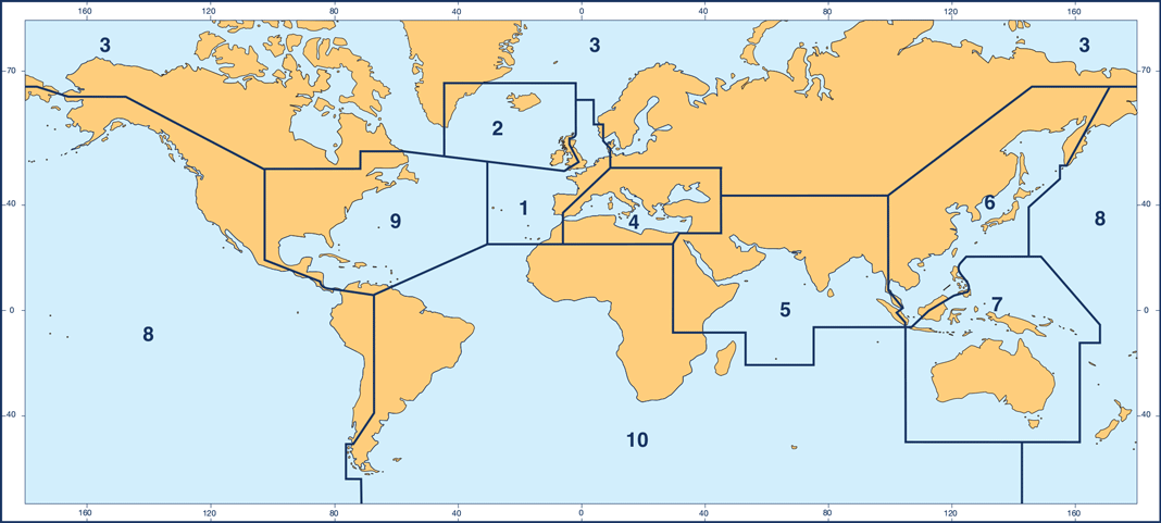
Below you’ll find issue dates for ARCS discs. Each disc corresponds to an area of coverage outlined in the diagram below. Please also note that RC11, which is not shown in the diagram, contains ocean charts (1: 3,500,000 and smaller).
Download the disc coverage diagram >
Who to contact?
You can contact one of our sales agents for help at sales@amnautical.com or phone +1 (954)-522-3321. Alternatively, you can submit your query on our website.
READY TO PURCHASE?
We offer ARCS in a variety of different price points, based on volume. Fill out the information below to set up a consultation.
looking for other digital charts?
We distribute electronic navigation charts for digital navigation with ECDIS.
Be sure to take a look at our Terms of Use | Privacy Policy | Support
American Nautical Services, Inc.
3311 S Andrews Ave, Suite 11
Fort Lauderdale, FL 33316
United States of America